

Traffic management is an everyday challenge for municipalities. Accidents, roadworks, congestion, and road restrictions can affect mobility and require a rapid response from municipal services.
Access to up-to-date information about these situations is essential to understanding what is happening across the territory and supporting more informed decisions.
Waze, one of the most widely used navigation applications, provides information about traffic conditions and incidents reported by its users.
Through the Waze for Cities programme, eligible municipalities and other public authorities can access traffic data and share relevant information with drivers.
But how can this data be transformed into a monitoring tool tailored to municipal needs?
With Mapify, a technology solution integrated into City as a Platform, municipalities can bring together Waze traffic alerts and display them on an interactive map, creating a web application without complex programming.
In this article, we explain how this process works in five steps.
Waze for Cities: Traffic Information for Municipalities
Waze for Cities is a programme that promotes information sharing between Waze and public authorities responsible for mobility and road management.
Through this collaboration, cities can benefit from information about incidents, congestion, and other situations affecting traffic conditions.
Municipalities can also share information about roadworks, road closures, and traffic restrictions, helping drivers anticipate changes to their journeys.
This exchange of information creates new opportunities to improve urban mobility monitoring and communication with citizens.
With City as a Platform, data from different sources can be integrated and presented through a shared geographical view, simplifying municipal operations.
1. Create a Dataset for Waze Traffic Alerts
The first step is to create a Dataset to store information about traffic alerts.
Each alert can include different details, such as the incident type, geographical location, and other relevant information.
As traffic alerts are associated with specific locations, the dataset must be structured to allow each incident to be displayed as a point on the map.
In Mapify, this configuration helps organise the information before displaying it in an application.

2. Automatically Retrieve Traffic Alerts
Once the dataset has been created, the next step is to connect to the Waze data source.
Waze for Cities provides authorised partners with a JSON data feed, accessible through a specific URL available in the partner portal.
In the original example, Mapify uses a mechanism known as a Data Feed to automatically retrieve this information.
The data feed is configured to run every 120 seconds, or two minutes, allowing the application to regularly retrieve the latest active alerts.
This enables municipal services to access updated traffic information without manually importing new data.
If access to the Waze Partner Hub is not yet available, Mapify also supports simulated data, allowing users to test the application during development.


3. Process and Update Traffic Incidents
Once the alerts have been retrieved, the next step is to organise the information and ensure the map displays only relevant incidents.
In Mapify, this is achieved through Workflows, which allow users to visually configure sequences of operations.
In the original example, a workflow receives the active Waze alerts and automatically updates the dataset.
With each update, previous records are replaced with the latest information, removing incidents that are no longer active and adding new alerts.
This process helps prevent outdated information from accumulating and provides a clearer view of current traffic conditions.

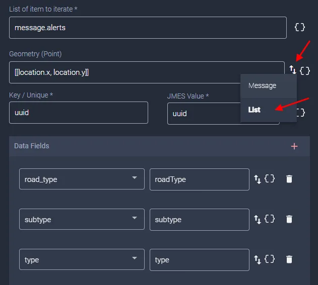

4. Display Traffic Alerts on an Interactive Map
With the data organised, the next step is to create a geographical data layer that displays the alerts on a map.
In the original example, alerts are represented using different symbols and colours according to their type:
Road closures: restrictions or interruptions affecting traffic.
Accidents: reported road incidents.
Weather hazards: adverse conditions that may affect road safety.
Traffic jams: areas experiencing congestion or slower traffic.
This visualisation makes it easier to identify where traffic issues are occurring across the city.
For municipal decision-makers, geographical visualisation supports situational awareness and helps identify areas that may require attention.


5. Create and Share a No-Code Application
The final step is to make the map available through a web application.
Using Mapify's visual tools, users can create an interface that displays traffic alerts on a Google Maps-based map.
The application can be configured to make incidents easier to explore, allowing users to see their locations and access the available information.
By bringing alerts together in a single environment, municipalities can provide their teams with a more integrated overview of traffic conditions.
The result is an application that transforms traffic data into accessible geographical information without requiring software development from scratch.
City as a Platform: Smarter Urban Mobility Management
Integrating Waze data is just one of the capabilities offered by City as a Platform, a territorial intelligence platform developed by Focus BC to support municipal and urban management.
In mobility management, the platform enables municipalities to integrate information from different systems, monitor incidents, and manage road restrictions.
These capabilities are particularly relevant to municipal departments responsible for traffic, mobility, public works, and public space management.
A real-world example is the Municipality of Lisbon, which uses City as a Platform to manage and communicate traffic restrictions.
The solution centralises information about road interventions and makes traffic data available through interactive maps, with integration with Waze and Google Maps.
Explore the Lisbon traffic management case study.
While this tutorial focuses on retrieving and displaying Waze traffic alerts, City as a Platform goes further by supporting the operational management and communication of road restrictions.
More than simply displaying alerts on a map, the goal is to turn mobility data into actionable insights that improve traffic management, support municipal services, and make everyday journeys easier for citizens.
FAQ
Common questions
Municipalities can integrate Waze for Cities data and display it on interactive maps. With Mapify, a City as a Platform solution, they can monitor alerts about accidents, traffic jams, weather hazards, and road closures through regularly updated information.
Waze for Cities is a data-sharing programme connecting Waze with public authorities. It allows authorised partners to access traffic information and communicate roadworks, road closures, and other restrictions relevant to drivers.
Yes. Mapify provides visual tools for configuring data collection and processing, creating interactive maps, and developing web applications without complex programming. Access to live Waze data requires the appropriate authorisation.
City as a Platform enables municipalities to integrate mobility data, monitor incidents, and manage road restrictions. Through integration with Waze and Google Maps, municipalities can improve the information available to citizens and support coordination between municipal services.
Categories: Mobility


